I will be on the North Shore in September fishing, hopefully, some of the rivers flowing into the lake. I’ll be in Grand Marais. I know there’s a drought right now but looking at USGS stream gauge numbers doesn’t help in visualizing the flow of a river. Has anyone been up there this summer? The only specific I’m looking for is how are the rivers doing regarding the flow. One of the days I’m up there will be on a guided boat trip for lakers out of Grand Marais. Any info on the river situation is appreciated.
Is there a fly shop in the area you are going to that you can call or check their website for condition reports in or near the drainage you plan to visit?
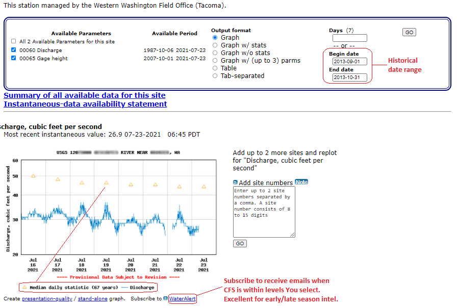
I don’t want to hijack your thread but as far as USGS stream gauge station data goes, three ways I’ve found that help me “visualize” river conditions from the data are looking at the current level data, the “mean”, and keeping detailed records of my trips.
For example my trip records (and memory) indicate this river, that is open “year-round” for trout, is a terrific “early spring” river because its headwaters are at a low elevation; only 3200’. The sections I like to fish are around 30 river miles from the headwaters at 400’. It’s also a “coastal” river with access to saltwater and in the fall big Sea Run Cutthroat come into the river (often several times) to gorge on eggs from spawning salmon and to spawn themselves, then return to the salt.
Rivers with headwaters near 5000’ usually aren’t fishable due to snowmelt and resulting runoff for a couple of months after this one drops into shape for early spring to early summer fishing.
The first things I look at in the USGS stream data are the CFS level, then the mean. If the water is higher than the mean, especially in the spring, it could mean turbid water and difficult wading - fishing conditions. If the water is lower than the mean in the summer and fall, it can mean low water, high water temps, and spooky - stressed, lock-jawed fish hiding in the only deep holes they can find. After that, I look at my trip records for CFS and how fishing was during previous trips at the current levels.
Didn’t record the CFS or remember the exact date of a trip where the fishing was outstanding or a bust? Use the USGS historical lookup just above the CFS chart and put in a Beginning and End date range for a previous trip. That can provide a good indication of how the fishing will be under similar conditions.
Given the current level of the river in this chart (a favorite), my records indicate poor fishing below 30 CFS. I will go to streams with headwaters at higher elevations until after we get some rain.
One more thing, I find the “Water Alert” system very helpful for streams I like to fish. It’s intended for notifying landowners who for example want to know when rivers are reaching flood stage. I use it to find out when the CFS reaches levels early (and late) in the season that my records (and memory) indicate are safe to wade and get to locations where I’ve been successful in the past, and the water was clear enough to effectively fish. I enter the highest water level I can safely - effectively wade and fish, and a level somewhat lower that the CFS is unlikely to drop to within one day to ensure I get the notification. Then I select the option to receive one email a day for each day the CFS is within that range.
Rob, I hope you are able to get the intel you need for your trip. And I hope this information on the stream data and features available on the USGS Current Conditions website is helpful to someone.
1 Like
I have no current conditions. I Tenkara fished the Two-Hearted and Fox rivers last August with a TUSA Sato. The Two-Hearted was very productive and standard techniques will get you fish. I struggled on the fox as I was upstream with heavy alders coverage.
Good Luck.
1 Like